Click to see larger photo
|
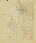
| Whittier Quadrangle (United States Geological Survey) |
| MAPS-00022 |
| Whittier Historical Visual Collection |
| Maps |
| Whittier Public Library |
| 1925 |
| Manuel Nieto was granted 146,454 acres of land in 1784, by Governor Pedro Fages. In 1834, this land was sub-divided into Rancho Los Alamitos, Rancho Las Bolsas, Rancho Los Cerritos, Rancho Los Coyotes (shown here), and Rancho Santa Gertrudes (shown here, misspelled Santa Gertrudis). Rancho Paso de Bartolo (shown here) was also originally included in the land grant given to Manuel Nieto, but the padres of the San Gabriel Mission contested this portion, so it was not included. In 1835, following the secularization of the missions, Rancho Paso de Bartolo was granted to Juan Crispin Perez. After the Mexican-American War, former Governor Pío Pico began purchasing pieces of the estate from the heirs of Perez (who had died in 1847), and by 1852, he had acquired 8,991 acres of the rancho. |
| Geological Survey (U.S.); Maps, Topographical; Nieto, Manuel, 1734-1804; Pico, Pio, 1801-1894; Mission San Gabriel Arcangel (San Gabriel, Calif.); Whittier, Calif. |
| VIEW COPYRIGHT STATEMENT |
| pdf |
| A.1.2 |
| http://digi.cityofwhittier.org/awweb/guest.jsp?smd=1&cl=all_lib&lb_document_id=24769 |
| 24769 |
|
|
|
|
|
|
|
|
|
|
|
|